Updated Thoughts on Perry Peak

Yes, I sometimes ski in storms. I have a particular set of criteria for considering it, and a particular set of places where I'll do it, in a particular set of ways, but as a matter of policy it's not off the table for me.
What is off the table is: I never combine storm skiing in the backcountry with avalanche terrain. That's not just a hard limit; it's an easy one. You can easily structure things so your avalanche risk is zero (or, at worst, mostly zero), which frees up bandwidth to worry about all the other storm-skiing hazards...
Exposure. Getting lost. All the weird things that can go wrong in a high-variance, high-energy context—including simple, stupid things that compound or collude in ways you're never seen before. Or maybe you just get clocked on the roads, which are probably their own disaster.
The point is a big Sierra storm on its own is more than enough to handle.
****
My avalanche philosophy, cut to the chase, might be something like: when you see giant rocks floating in the sky, avoid walking beneath them rather than trying to figure out which ones are going to fall.
That's an over-simplification, obviously. But maybe it's useful. Not all of life has to be rocket science.
****
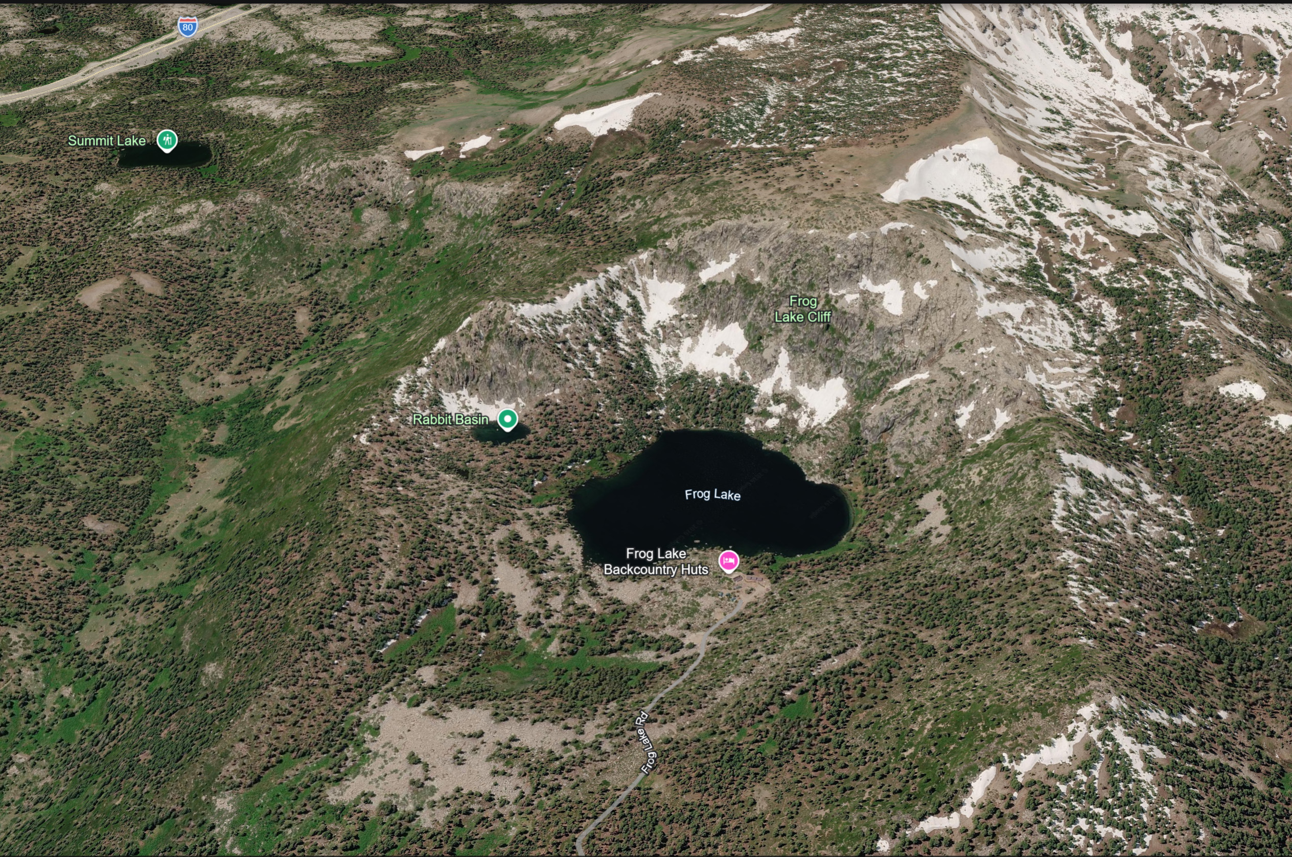
I'm not familiar with the Castle Peak area or the Frog Lake Hut, so I looked it up in Google Earth. I've rotated a screenshot so northeast slopes, where we typically expect maximum avalanche hazard, are facing toward you (in North America, NE aspects tend to wind-load because our prevailing winds come from the SW).
There are obvious safe paths from the hut to the freeway, but they're either circuitous or narrow.
In a true monster of a Sierra storm, you'd probably want to minimize your travel distance. You'd probably also want to stay bunched up, so no one got lost. And unless you were being very sharp with a compass or GPS, it would be very easy to wander into trouble.
****
I admit I feel angry here. Under those conditions, going on a Nordic tour with a group that size would have been dangerous—structurally compromised. I cannot imagine a justification for adding avalanche-capable terrain to that equation. It's very hard to understand.
I'm horrified.
****
NYT has an article including quotes from two of the survivors. Also, there is now a preliminary incident report at the Sierra Avalanche Center which includes photos and limited but useful information about the size and location of the avalanche.
Together, these two sources let us ask a really personal question: would my own radar have been tripped?
Unfortunately, the avalanche was buried beneath subsequent snowfall before SAC could safely get there to measure it. As they note in their report, "The trigger, slab thickness, depth, width, and other details of the avalanche remain unknown and may never be known, as the storm buried the evidence."
According to SAC, 13 people were buried. SAC says "victims" — not clear if they mean deceased or all 13 — "were all buried in a small depression" — ie, terrain trap — "in a small area (20' x 20') near the toe of the avalanche debris."
That 20' x 20' detail is jarring.
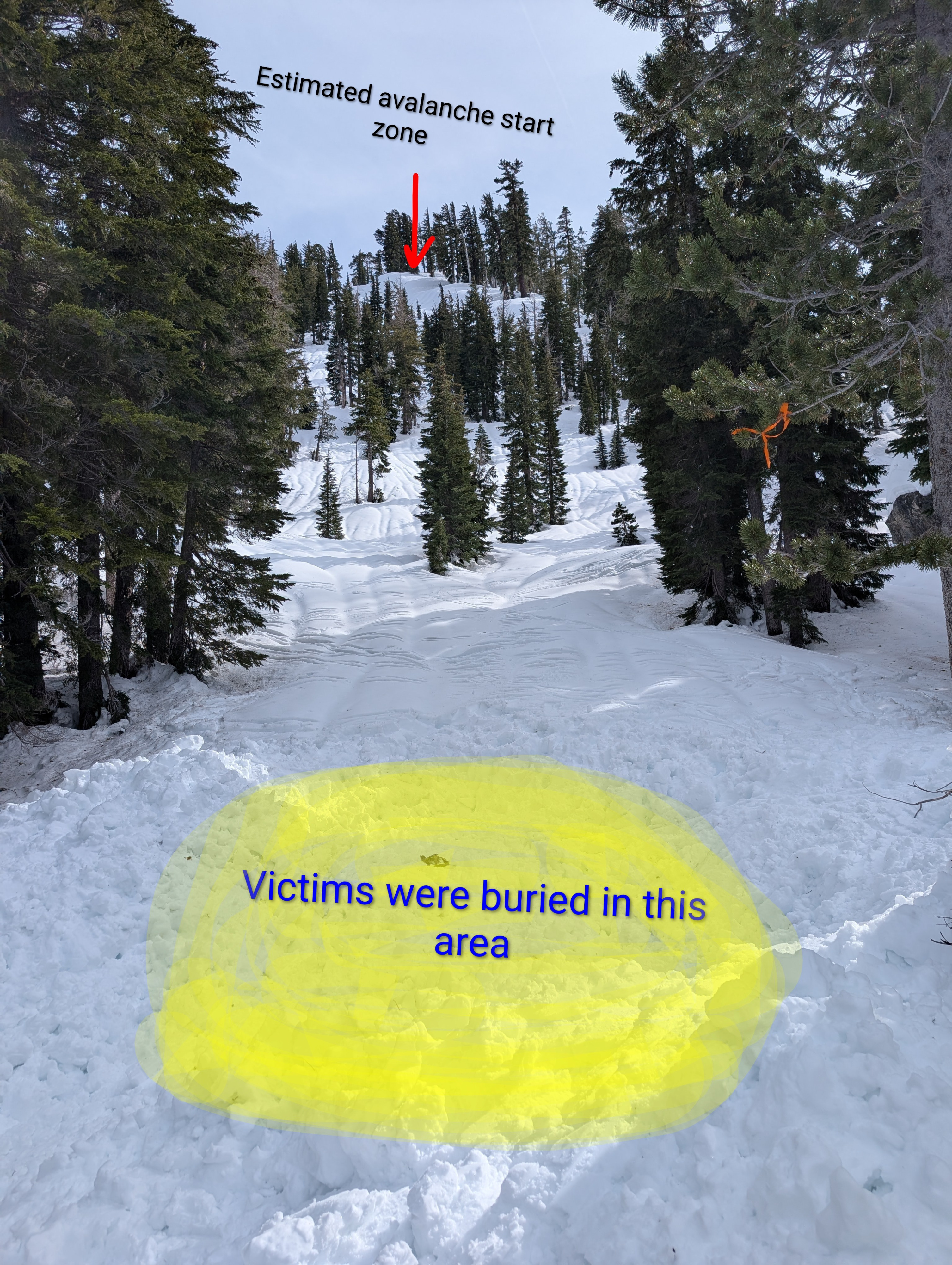
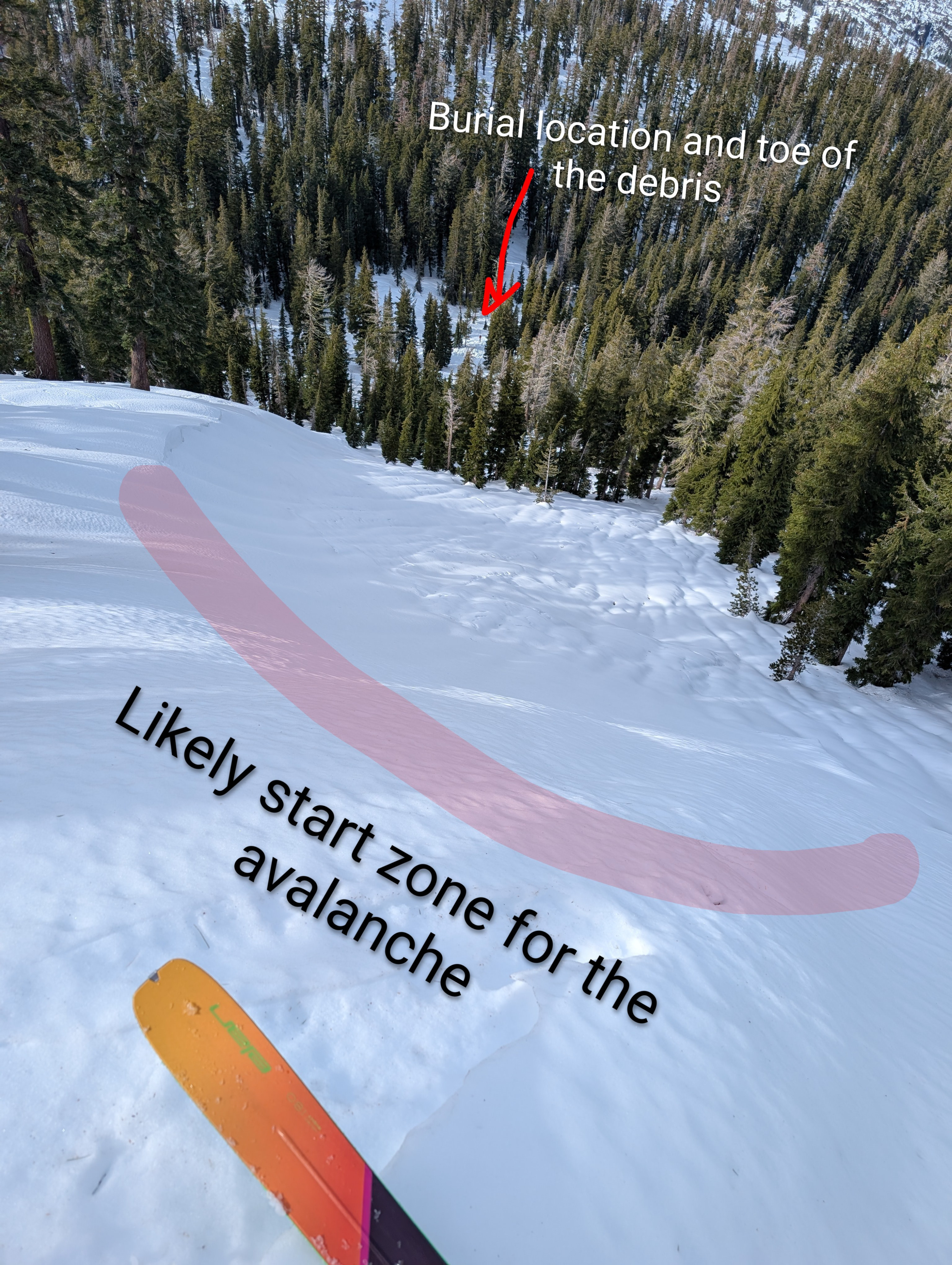
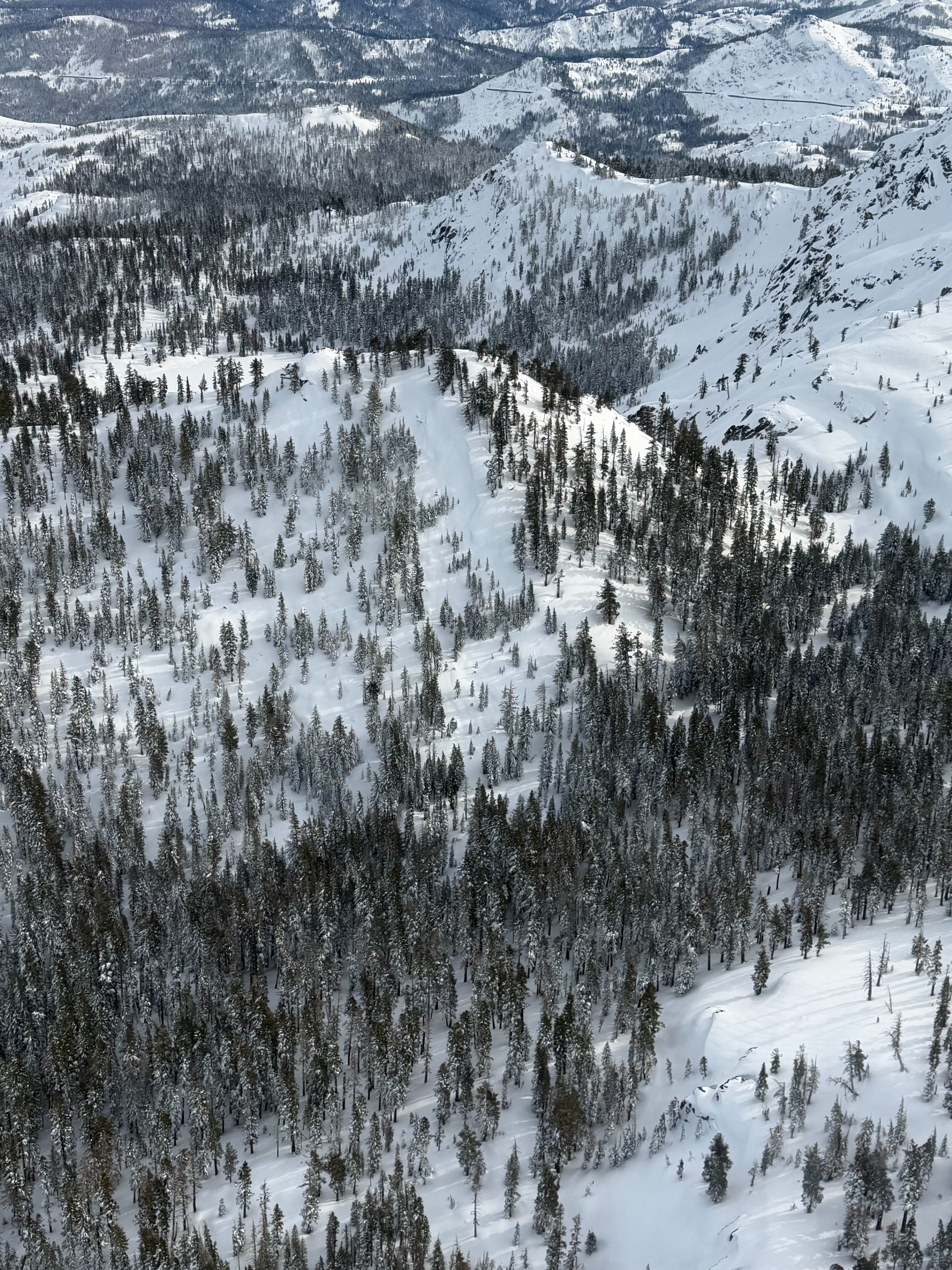
This strongly implies the group was bunched up or even stopped at the time the avalanche struck. I copied three of SAC's photos here, because I think they give us what is probably going to be as good a story about what happened, and why, as we're going to get.
Photo 1 shows the burial site from the victims' point of view. Photo 2 shows the burial site from the avalanche's point of view. Photo 3 is an aerial overview of the entire area.
From the victims' point of view, there was a small slope/potential ridgeline trigger zone above them, with a healthy stand of trees serving as both a barrier and a historical indicator that major slides through this area were unlikely. Obviously, at the time of the slide, all of this was obscured by blowing snow, but travelers familiar with the area (ie, the guides) would probably not flag this as a high-risk slide path.
Now, anyone who climbed that peaklett on a sunny day and looked down — Photo 2 — would have gotten a very different perspective on the potential hazard. Here, it's clear you have a 37-ish degree NE-loading ridgeline that feeds directly into a potential terrain trap. Photo 3 completes the context: yes, that's a small but credible funneling avalanche zone with a very localized but also very nasty terrain-trap at the bottom.
****
I want to make clear I disagree with the decision to take that group out into the storm at that time on that day.
Forget the avalanche danger—the situation on its face was dire the moment they left the hut. Deep snow would have been exhausting for non-elite backcountry travelers to push though. Ditto high winds and whiteout-conditions, which would have disoriented the group members and compromised their balance, further escalating fatigue.
If any one of the clients got separated from the group, they probably would have died. And where did they think they were going? I-80 was closed. And to get there, their planned route (over a high, bare, N/NE saddle) would have taken them directly into the fiercest winds of the day.
Venturi-effect winds at that saddle could have topped 80mph. That much wind would repeatedly slam you to the ground, making forward progress almost impossible.
There were fifteen of them.
****
But that first photo... that, to me, tells the tale. According to the NYT article, the group at least initially traveled one-at-at-time when they were crossing presumed avalanche paths—standard etiquette to minimize group exposure. So why were they so close together below Perry Peak?
By that point, the guides' bandwidth was probably just about spent. They, too, were being hammered by the storm, and additionally carrying the cognitive load of being responsible for 11 likely-disoriented and exhausted clients.
Even at the toe, the slide path they were crossing was narrow—probably not more than 100-200 linear feet wide. And there were plenty of reassuring signals (healthy, unmarked trees) that they weren't in an active slide path. Traveling one-at-a-time past every theoretical hazard would itself be dangerous—too slow; too much risk of getting separated.
****
When they left the hut, the number of things that could go wrong increased dramatically—terrain and routefinding challenges multiplied by the storm and multiplied again by fifteen people and all the complex interactions between them.
It's tempting to want to wrong-place, wrong-time this story: to imagine that if they had reached Perry Peak a little earlier (or later) that day, everything would have been fine. But in that storm, there were structural hazards every step along the way.
Bottom line:
1. At the time of the avalanche, the guides' free capacity was low and environmental demand was high.
2. Visible slide path signals were low to nonexistent; avalanche hazard could only be inferred from prior topographical study paired with precise location tracking in whiteout conditions in real time.
— February 18, 2026
Andy Lewicky is the author and creator of SierraDescents
Dan Conger February 19, 2026 at 1:45 pm
I simply can’t understand how the guides made that decision. The slopes there are ~35 degrees, which is perfect for large slides. That decision in those conditions is incomprehensible to me.
Andrew March 10, 2026 at 8:42 am
This is a great, fair-minded analysis. Thanks for posting, Andy.
Yuri Lewicky March 24, 2026 at 11:12 pm
Excellently written, loved the pictures and details. Thx brother😊
Bradley Brown April 25, 2026 at 5:49 pm
An excellent analysis. I’ve studied enough of these accidents to know timing is critical. Jermey Jones finished a route fairly early one morning in the Alps and shortly after the whole slope ripped down to dirt-wet slide I believe. His comment was “timing is everything in the mountains” (source, Powder Magazine, don’t remember the date). You personally dodged a wet slide a few years back where timing was EVERYTHING only being saved from getting flushed bc of passing water to a partner. To your point the best move was to not to be there in the first place. Bob and I declined to advance from Red Lake to Split Mnt late September 2022 bc we had 50-60 mph winds at 10,400 and deduced they would be hurricane force in the class 3 zone and worse on the ramp to the summit. Though a bummer I’m happy with the decision-Split is still there as of 4-24-26 when last seen (barely) clouds moved in). We’ve all been out in the sh…t before and know how challenging it can be. Cold, fatigue, wind that sucks the life out of you, visibility, elevation, hard to access gear, hard to eat/drink/communicate, conditions induced brain fog, ad infinitum. All of which can be avoided by waiting a day or so. Your analysis of grouping under the circumstances is astute. I originally figured tight spacing was causal but as you note conditions may have favored bunching up. In blowing snow massive loading could easily be overlooked. I wouldn’t be surprised the guides had never seen slides in this area nor envisioned the terrain trap which you note is more obvious from above. In Karate Kid 2 there’s a scene where the kid tries to get back at Sensei for a lesson with a swinging bag on a rope. When done to the Kid he attacked it, when done to Sensei he merely stepped aside commenting “Best block, no be there”. No be there is your conclusion. But once under way they may have done as good as anyone but just fell victim to “…..timing is everything.” RIP to the victims and fams.