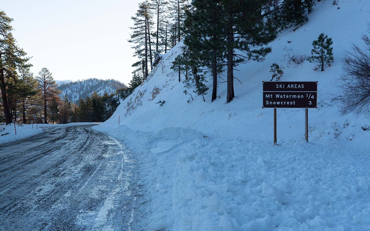
Waterman & Highway 2
I would like to wholeheartedly endorse the Waterman-Buckhorn-Highway 2 area as Southern California's best go-to and introductory backcountry skiing zone—but I can't.
The positives: it's close! About 45 miles from downtown Los Angeles, with most of the drive below 5000 feet and so unlikely to be snowbound. The terrain in this area is diverse and lively, true-north facing, and expansive.
You get great panorama views of the L.A. basin, the high desert, the mountains, the ocean, and, on clear days, the High Sierra. You also get three variously defunct ski areas (Waterman, Kratka Ridge/Snowcrest, and Buckhorn) which you can freely access, and whose runs don't tend to need a lot of snow to be skiable.
So what's the problem?
Ice. The face of Waterman is big, steep, open...and almost ubiquitously icy. It's icy on days where I find myself thinking it can't possibly be icy up there. It's icy even when it looks like it's not icy. It's icy to the point that I sometimes wonder if what really killed off Waterman, even more so than lack of snow, was the difficulty of managing all that damned ice.
Paired with ice, our beloved 'diverse and lively' San Gabriel terrain can repeatedly put you in bad situations if you're not careful. There are lots of little complex gullies which all look alike and which can all roll into treed shadows where friendly edgable snow abruptly goes skittery and hard.
All those steep pitches on variously north aspects at least raise the specter of avalanche hazard. If you are looking for big, classic slide paths you won't find them here, but do note those little gullies can create micro terrain traps which can make even small slides unexpectedly dangerous.
Buckhorn is by far the safer choice if you want lower-angle terrain, though even here you may find little terrain traps in the adjacent gullies (or they may find you).
While it is a short drive from the city, Highway 2 can be very erratic in terms of snow closures, and Caltrans' website often gives inaccurate information. Part of this may be subterfuge designed to keep hoards of weekend snow play and street racer traffic away.
Finally, be aware (if I'm reading the map correctly) that the entire north aspect of the crest from Mount Waterman to Windy Gap is currently under a closure order due to the Bobcat Fire. Luckily, Waterman and Buckhorn did not burn, but they are nevertheless (I assume) closed to public entry until the order expires on April 1, 2022.
There are large burn scars on Islip and in the main gully between Buckhorn and Waterman. In addition to ash, debris, and generally crappy skiing, you'll find deadfall hazard in those areas, so I'd recommend staying away from them even after the closure lifts in April.
— December 19, 2021
Andy Lewicky is the author and creator of SierraDescents
Justin P December 20, 2021 at 4:03 pm
Found out about those gullies the hard way. First trip there, took one wrong turn on the descent and ended up on the wrong side of one of those gullies. When we finally made it out, had to hike about 1.5 miles back to the car…
Brad Brown December 22, 2021 at 6:16 am
Well Bob and I skied Krackjaw ridge in the 90’s on 12” of new “pow”,
aka unskiable April glop…what ice!?!? . Single chair lift and “warming hut” was a return to yesteryear. Waterman face impressed back then and now the website reveals 1K of vert and $30 senior rates, hmmmm!?!?. Add an hour + savings on high gas prices just might offset the Ikon pass math!?!
This Friday marks a 1/2 century of sliding, so blessed to be skiing anywhere and still arc ‘em. And yeah pray for snow…
Louis Tremblay December 22, 2021 at 1:11 pm
Andy it begs the question then, where IS the best spot :D
Andy December 23, 2021 at 4:37 pm
Louis I was kind of hoping for some suggestions on that. I was specifically thinking about places that would be friendly for people wanting to get into SoCal touring. Will probably write up something formal this season because I do get a lot of people asking for recommendations.
Quickly: Pinos when the road isn't jammed. Easy Alpine and lots of nordic-style touring, probably hard to get lost, probably hard to get in trouble...mostly.
East Face San Jacinto. Accessed via tram. Probably very safe in terms of snow stability (other than terrain traps if you take the wrong line in the gullies!), but easy to get lost if it's stormy. Benefit is you can follow the boot pack of the regular snowshoe climbers which would keep you out of trouble.
East side of Sugarloaf Mtn Big Bear accessed via HWY 38 -- a wild guess here because I haven't skied that route. But thinking easy treed glades at low angle and non-complex terrain? This is a guess!
Baldy Bowl -- lots of concerns here, but it's a very popular route so you won't be alone, hard to get lost.
Buckhorn off Highway 2 -- low angle glades and trees.
Sean S December 24, 2021 at 11:00 pm
This is all great information, thank you! I have a lot of BC experience from my time living in Utah and just moved to San Diego in July. The SoCal mountains certainly came as a pleasant surprise. I summited baldy, san jacinto, & san gorgonio in my first month here.
I am now looking to start touring. I see there is no regular avalanche forecast for any of the ranges and not much information. This website has definitely been my best resource. A couple questions I have:
1). Do you think San Jacinto has enough coverage yet to take the tram up and ski something east facing from the summit back towards the tram?
2). I see your recommendation for Buckhorn. Does that highway 2 close during storms in the winter?
3). What would you recommend for someone looking to get a tour in this week by themselves? So looking for something low angle without steep aspects above. I am considering the two options above or something low angle around Gorgonio. Any recs would be greatly appreciated! I appreciate the recommendations given above.
Louis December 25, 2021 at 6:40 am
Thanks Andy, those spots align with what I suspected. Agree with Sean, your website has been invaluable and the old Daniel Anderson guidebook was written when touring meant something else...Thanks again!
Sean: check out the tramway cam, SCASC reports on facebook, and the various ski centers, for some semi reliable condition updates.
Sean S December 25, 2021 at 10:50 am
Thanks for the tips Louis! Much appreciated
Ian B December 27, 2021 at 1:17 am
One thing I'm worried about is the upcoming storm cycle. We have a trio of cold storms at our doorstep, followed by what looks (on the 7-10 day model) like another pineapple express scenario first week of January. That would either put rain or cement on top of deep, multi faceted layers. Fingers crossed.
On an icy note, had a blast on Baden on the 18th of December. Even rode down to the 2 in what I thought would be too low tide of conditions. Boy was I wrong. No even a nick. Although, our last 150+ yards to the road was an ice rink. Brought mirco spikes to an axe and crampon fight. Took my partner and I two hours to get down what would take 20 seconds. We were using my avi shovel to dig steps, since we couldn't even kick em in. Serious slide for life stuff. Absolutely not fun. Lived and learned.
Andy December 27, 2021 at 10:20 am
In the SoCal ranges I worry about ice more than any other objective threat. And it's absolutely gotten worse. Have now heard a number of reports of microspikes being overwhelmed. Thanks for sharing that and please be careful out there!
Bob Newton January 15, 2022 at 4:21 am
As a member of the Whittier Ski Club, now Buckhorn, I have had a few ice days. I patrolled Waterman in the 70's and spent many days at Kratka. I had many more great, including fresh powder days. A few with only new tracks every run. The old foothill area is best.
Bill February 5, 2022 at 7:30 am
The ice and steepness at Waterman is no joke. Waterman owner Barry Stubblefield died there in 2005 after slipping and being unable to stop his sliding.