The Thumb - Southeast Face
A California Backcountry Skiing Classic
Birch Creek, California — it's 6:00 a.m. and all is quiet. We're crossing marshy grassland beneath Sierra foothills, looking for an on-again, off-again trail which we hope will take us to an enigmatic subpeak along the Palisades crest known as "The Thumb."
The Thumb takes its name from its appearance. Seen from Big Pine and Highway 395, it is a distant, triangular peak with an abrupt southeast ramp shaped much like the upward curve of a hitchhiker's thumb.
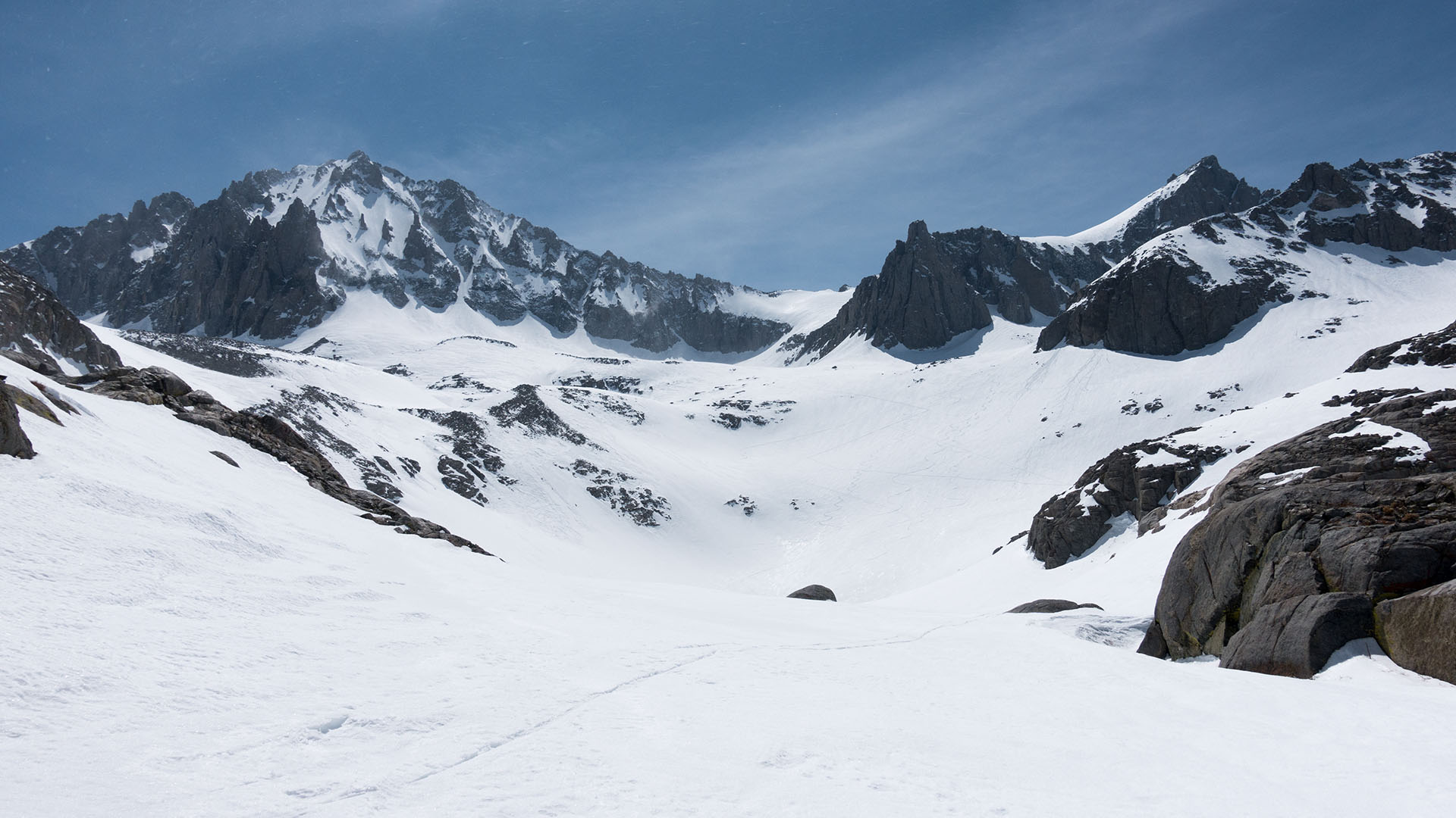
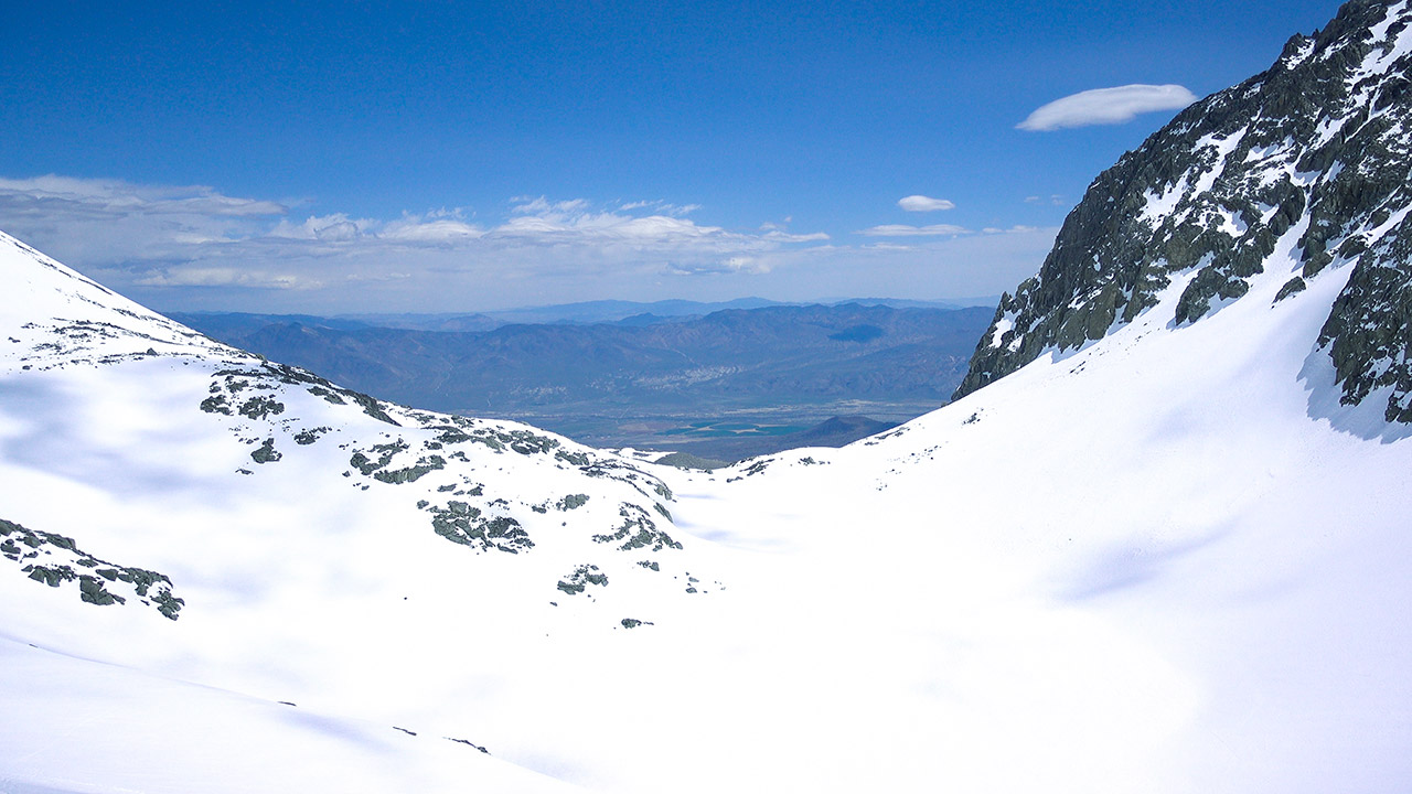
Between us and the Thumb's summit lie a vast stretch of open cirques and glacier fields—the Birch Creek Drainage, which includes Birch Lake, and which winds its way below the striking granite of Birch Mountain's north face.
As terrain goes, the landscape is big, wide-open, and moderate—at least as far as skiing is concerned. And that's what's brought us here today. In guidebooks the Thumb has a reputation for great skiing, plus great views.
This is Palisades country, after all.
Of The Thumb, author Paul Richins says, "There is no better ski summit in the Sierra"—no small endorsement. We'll happily take any measure of good skiing today, and from the look of it, that's exactly what we're going to get.
Thanks to the record storms of the 2016-2017 winter, we've got a huge Sierra snowpack gleaming white in front of us. The forecast calls for cool but not cold temperatures, and just enough of a breeze to keep the snow from getting too ripe on the descent.
That breeze will likely come in handy. From the trailhead at McMurray Meadows we've got a considerable 7000 vertical feet of climbing ahead of us—a long day, by any standard.
Of Rights and Privileges
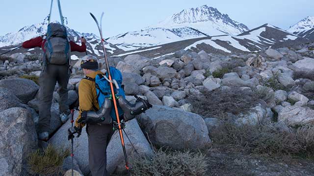
As the sky lightens marshy meadow gives way to strewn and scattered boulder piles, old glacier debris deposited here long ago. Having grown weary of its tendency to vanish, we've quit the Birch Creek trail and are steering toward a finger of snow (ironically, perhaps) which we hope will keep us on-snow all the way to The Thumb itself.
That plan goes awry early, despite my efforts yesterday to scout out the approach, as we discover Birch Creek is right in front of us, in a hidden willow-choked ravine that doesn't remotely look friendly for crossing.
Back to the trail we go.
The trail gets us across the creek via a boulder hop—a touch too exciting this early in the morning. Crux thus passed (or so we hope), we promptly lose the trail again, and once more steer back to the snow finger.
Up or across?
We can go straight up the snow finger, but the snow is a little too firm for comfortable booting at this hour, and none of us have crampons. So plan B is enacted: we will traverse over to the snowfields below Birch Mountain, expecting those will connect us to the main bench that guards the drainage above.
This meandering, backtracking, and hopping around—all in service of trying to get on-snow and on-route—is an Eastern Sierra tradition that for me evokes no small amount of memories.
As we climb I'm traveling back in time, lost in 2011, the last big Sierra snow year. In 2011 I climbed one big glorious Eastern Sierra line after another, not in the least suspecting it would be six years—six years!—before I would return to the eastside to try my luck on a big route again.
Much has changed, in those past six years, including both mountains and me.
To my eyes, the range itself is different: warmer, windier. The snow levels, even in this record year, are higher spring-on-spring, and alarmingly so. April today reminds me of the June of yesteryear, particularly if you look at it from the south.
And as for me, I am unquestionably...older.
Somewhere, in our past six years of drought, it dawned on me that whole years—whole prime years of my ski life—were evaporating. Precious years, irreplaceable years. Sierra years. 7000 vertical feet of climbing (or more!) places demands on the body that cannot be waived away with a magic wand.
I've lightened up, gear-wise, and by golly that helps. But after so long a hiatus, I've picked The Thumb, here, as my return to the Sierra for two key reasons, and great skiing really isn't one of them.
In terms of technical difficulty, I want something easy, first of all: no chance of getting lost, no chance of going off-route, and no exposure. But I also want something hard, Eastside Hard, so I'll know, right away, whether or not this is a ballroom where I can continue dancing.
The Glories of the Eastern Sierra
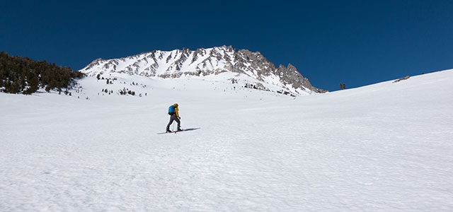
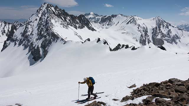
One of the things I love about the Eastern Sierra is that it starts out spectacular and then just keeps getting better. As we near Birch Mountain, the view of Owens Valley, to our east, is inspiring.
Then we round Birch Mountain's north face, and enter the Birch Creek drainage, and the terrain somehow magnifies. But there is a catch today: the wind.
Ever since the snow finger, the wind has been stiff in our faces, pressing us downward as we try to go up. Now crossing 10,000 feet in elevation, and entering the wide open spaces of the upper drainage, the wind abandons all pretense and ruthlessly blasts us.
The good news, I guess, is that we're not going to have to worry about the snow getting too mushy. The bad news, given this shrieking banshee of a wind, is that the snow may not soften at all.
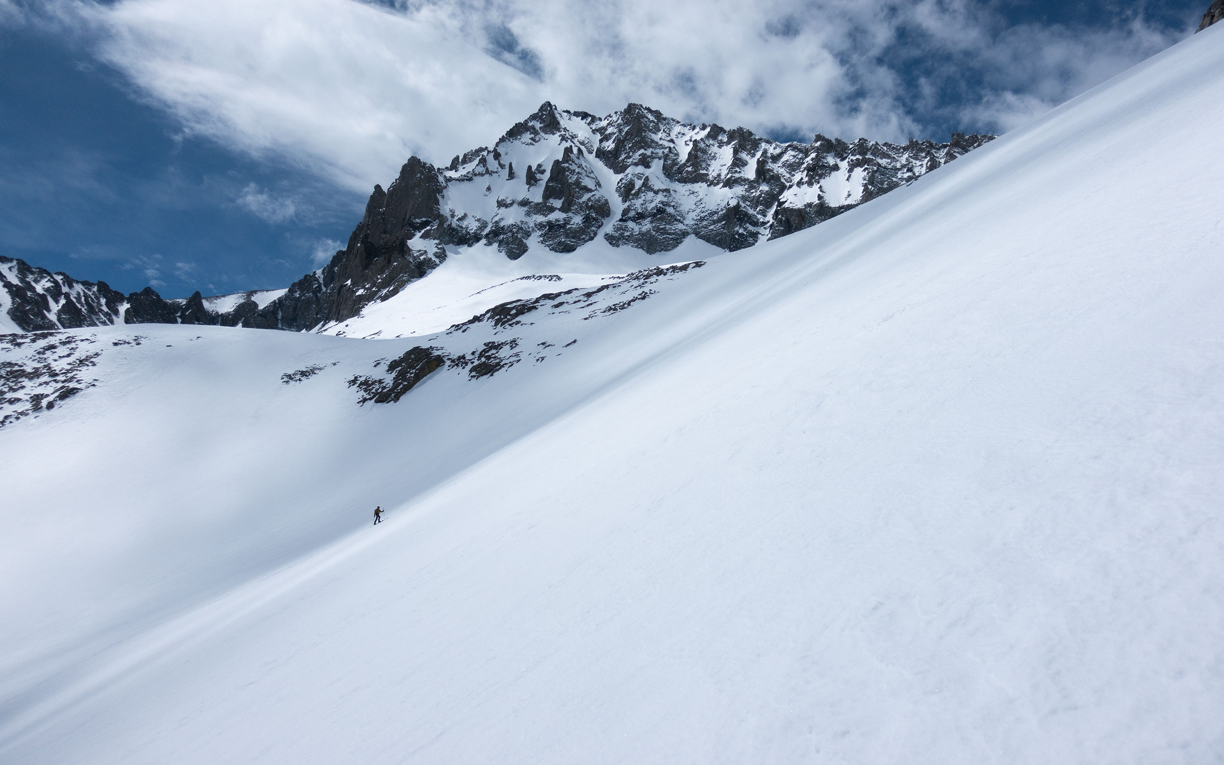
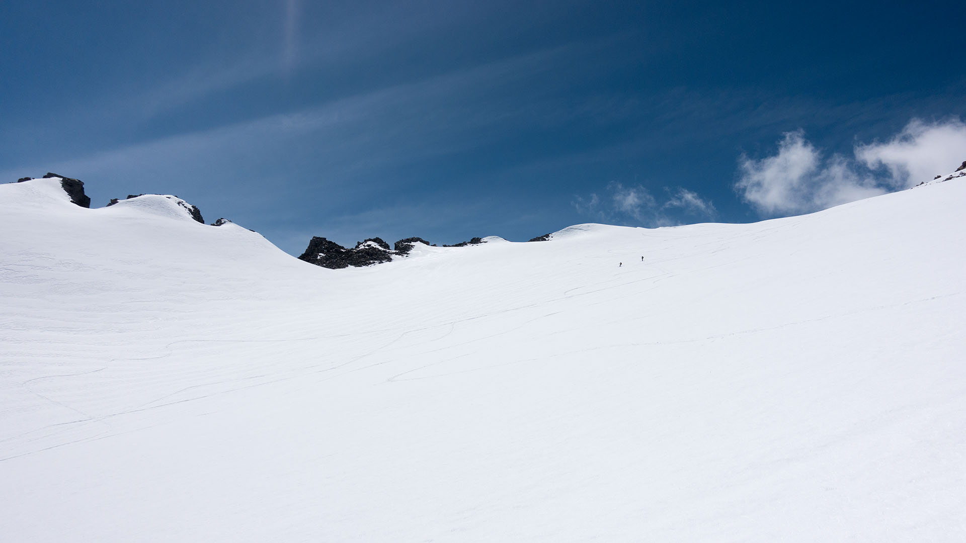
And my suspicion, as I bend over my ski poles and halt in my tracks, waiting for a particularly strong gust to spend itself, is that this is going to prove to be the quiet part of the journey. The crest, high above, looks menacing—streaked with snow contrails and racing cloud wisps.
As miserable as it is for climbing, it is magical for photography. Patterns of shadow race across vast white snowfields. The sky is brilliant blue, crystal clear. Black granite thrusts boldly upward, puncturing that sky.
And in the midst of nature's spectacle, we tiny humans ascend slowly upward, motes of dust in a maelstrom of elemental forces.
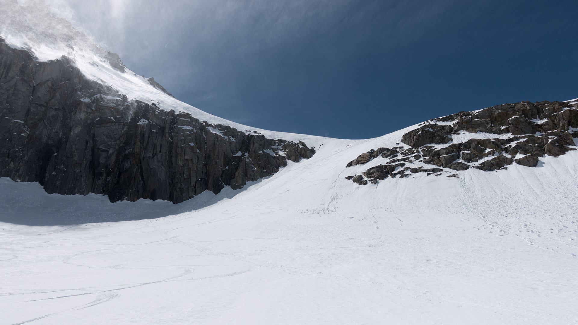
Above the utterly frozen-over and snow-covered Birch Lake is the headwall couloir that leads to The Thumb's southeast ramp and summit snowfield.
This is a modest pitch, probably in the 30-35° range at its looker's left (south) end, a bit steeper to the right, as it blends into the headwall cliff that extends beneath The Thumb's true summit.
The wind, for a moment, quiets in the bowl-like amphitheater here, though clearly there is no such respite on the crest above.
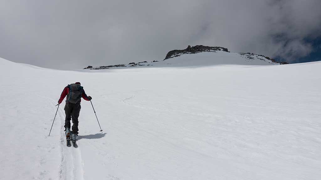
We enter the hot-cold phase of the climb, where whatever article of clothing you happen to be wearing at any given moment proves to be either too much or too little, depending.
The sun comes out, and it gets warm, and I peel off a layer, and then the wind peaks up again, and clouds swirl overhead, and I'm cold again. I try keeping my fleece half on, half off, which results in the dubious accomplishment of half of me being too warm and half too cold, simultaneously.
I'm tired.
I'm happy, here in my not-quite newly achieved Old Man status, of how well I've managed the climb so far: some hot spots in my boots and a bit of coughing and gasping, but otherwise I've been solid.
But now the air feels thin and my legs are giving off little warning flutters that tell me they've just about had enough of all this foolishness.
Hey, I tell myself—and my skiing partners Preston and Todd, who are also wondering just exactly how much farther we have to go now—we're really close to the summit. Just another few hundred vertical feet.
I am of course totally lying.
O.K., I don't really know how much higher the summit is. But I do know it's best to fudge the numbers a little at this phase of the climb. In any case, if you ever want an accurate count of how much higher it is to the top, don't ask me because I myself don't want to know.
And Now Comes The Wind
Cresting the headwall couloir brings us within sight of what I immediately take to be The Thumb's summit, which happily appears to be no more than three hundred vertical feet or so away.
My partners, however, appear to have grown skeptical of my distance and vertical pronouncements. They're convinced we're looking at a false summit. In fact, say they, the top is a solid thousand vertical feet away.
That I find simply too terrible to be true. The reality, however, is that we're both right, partially. That is The Thumb's summit—and, thanks to a most unhappy trick of perspective, it's a full fricken' 1K away.
Ordinarily I'd spend all my feeble remaining energy complaining about it, but there is instead a far more pressing concern: the wind!
The wind, alas, has reached an intensity such that I must stop after practically each step simply to crouch forward over my poles and try not to get knocked over.
When the wind catches me full in the chest it's powerful enough to actually threaten to flip me end-over-end, necessitating a painful, hunched-over stance, like a bent supplicant before a wrathful god.
This, my friends, is misery incarnate. Were I not here with two others, I'd be heading down rather than fighting to take these pitiful slow erratic lurching steps upward.
From time to time, I dare to raise my eyes into the wind to gaze at The Thumb's summit, from which clouds peel violently. Each time I say the same thing:
Damn.
There's just no chance we're going to make the summit today. As bad as things are, we're actually in a wind shadow right now, with the crest to our west.
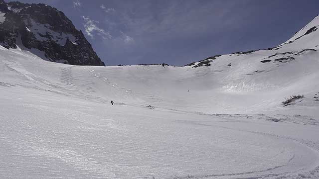
We top out eventually at a small nook some 80 vertical feet below the summit, overlooking Middle Palisade. This is as high as we can safely go. The wind is simply too fierce above to chance going any higher.
Transitioning to ski mode is no easy task.
The wind threatens to carry everything unguarded off to infinity. You name it: skins, clothing, pack, poles, even skis, everything has to be held down.
In these raging wind blasts the air feels bitter cold. I've got to chip ice off my ski bindings to get them to flip out of touring mode. I don't even bother trying to fold my skins nicely, I just stuff them in their sack.
We'll deal with them later.
It hurts, not making the summit, not getting to enjoy the no-doubt magnificent Palisade views that are just inches away from us, but this wind is ridiculous.
Yes, there to the south of us is Split Mountain, and its big snowy north ramp. Yes, there to the east of us is Birch Mountain, fine looks all. I can barely bring myself to care.
I try to pull my hat lower across my ears to block the painful wind-shriek. I clench my frozen fingers to try to get some blood back into them. I fight to get my skis on without loosing them to the wind.
Every impulse screams get down now, get of out this insane wind, and so that's what we do.
So...How Was The Skiing?
Descending The Thumb's southeast face
First turns beneath the nook we've been hiding in reveal the snow to be brick-hard, frozen solid by the merciless wind.
I skitter-slide a bit downward, trying to get a feel for it, but quickly the ice gives way to a mixture of wintery and manky spring snow, all of it unfortunately refrozen by the wind into something closely resembling a breakable crust.
It looks good, but it sure doesn't ski good.
Preston, Todd, and I are forced to adopt a hybrid snow-plow/traverse strategy of survival skiing. If snow and spent legs weren't enough to make the skiing challenging, there is the wind, which capriciously blasts us from alternating directions, forcing us to go down in the exactly the same way we've gone up this mountain: bent over and paranoid.
No Problem, say I.
As soon as we get to the headwall couloir, and out of the wind, everything is going to ski just fine. And even if the couloir isn't great, we can pick any aspect we choose for the ride down the drainage, assuring us good skiing.*
(*attentive readers may note this bright and cheery tone is suspiciously reminiscent of Andy's speech when talking about elevation numbers)
We've reached that point in our journey where ordinarily the drainages open up, the air warms, and there's nothing much to do except enjoy thousands and thousands of vertical feet of great skiing in the most beautiful setting imaginable.
The beauty, to be sure, is here. A baby-blue sky beams over the warm hues of Owens Valley. Gleaming white snow, high above, stretches in all directions here in the Birch Creek drainage.
But the snow, on the headwall couloir, remains far too grabby for safe and enjoyable skiing, and beyond that, the vast and open snowfields of the drainage, one by one, also fail to deliver a consistently-edgeable surface.
And the wind, impossibly, seems even stronger now on these lower elevations. If anything, the snow is harder now than when we were climbing up it, hours earlier.
I try in vain to find a viable aspect.
By traversing I can shift from true north to due east to true south aspects. Not one of them offers good skiing. That we must laboriously crab our way down this otherwise glorious landscape is a bitter pill, indeed.
Finally, as we pass below 9,500 feet, the snow warms enough for reasonably smooth skiing. The wind, while not quite so savage as above, still refuses to quit, however.
On our way up, as we left McMurray Meadows and began ascending the snow finger that we hoped would connect to the drainage, I joked that the finger would make for the best skiing of the day.
That not-quite prediction proves to be exactly true.
Birch Gives Us The Finger
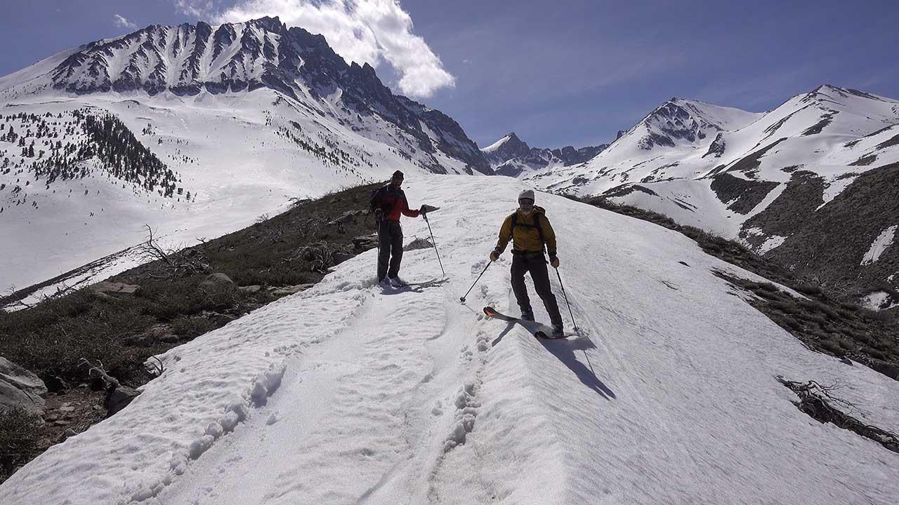
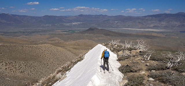
Birch Mountain's 'fingers' of snow are a curious feature found on the massive peak's lower flanks. I've seen—and skied—them before. Today, they extend a surprisingly long way down and into the desert, allowing us to stay on skis long past the regular snowline.
And the skiing is at last good!
Warm, sun-kissed consolidated spring corn, exactly what we were hoping to find thousands of feet above us. Where were you, we are all thinking, when we needed you?
No matter. Instead of having to hike down, we are able to follow the snow finger all the way to 7000 feet or so, making for a very easy return (creek-crossing notwithstanding) to the car.
And there you have it: a successful return to big mountain skiing, Eastern Sierra edition, after far too long an absence. For me it has been a happy one, despite the wind, despite the awful skiing. It feels so good to be back out there, once again.
I tell Preston and Todd this is the best horrible day of skiing I've ever had—and I mean it.
It is easy to forget, after easy years of big snowfalls and many successful tours, that ultimately our travels in the Sierra are not a right, but a privilege.
We are each of us granted a certain window of time to go forth and find our adventures out there. I don't know how long my window is going to be open, but six years of drought have certainly narrowed it.
That could spur feelings of desperation, I suppose—a frenzied rush to ski as much as possible, while I still can.
But it could also foster a better sense of appreciation, a finer gratitude for what nature has granted us here along the magnificent spine of the Eastern Sierra—and to keep as precious however many years we have, each of us, to experience it.