National Geographic Topo!
- detailed route analysis
- 3D rendering
- print any map
- recommended
Mapping software has come a long way from its early days, with National Geographic's Topo! series now established as the king of the hill.
Topo! has a sophisticated set of route-profiling features, and the package has recently been upgraded to include 3D rendering tools. Prior to software-based mapping, if you wanted the complete set of California USGS Quads, you'd need to buy over 2,800 paper maps. Thankfully we now have Topo! which offers the convenience of being able to instantly access any quad at your desktop. You can also draw routes directly onto the maps, and then display complete route profiles: elevation, distance, slope angle, and aspect.
Want to see just how miserable that slog up Williamson's east side was? Retrace your route in Topo!, read the results, and weep. Concerned about that approach to the Kaweahs? Draw your planned path in Topo! and pack extra trail mix.
Topo also interfaces with GPS devices, allowing you to upload or download waypoints between the two—a very handy feature, if you're a GPS user. Just create waypoints on your GPS as you're hiking.
When you get home, import the waypoints into Topo!, and the software will show you your exact route, point by point.
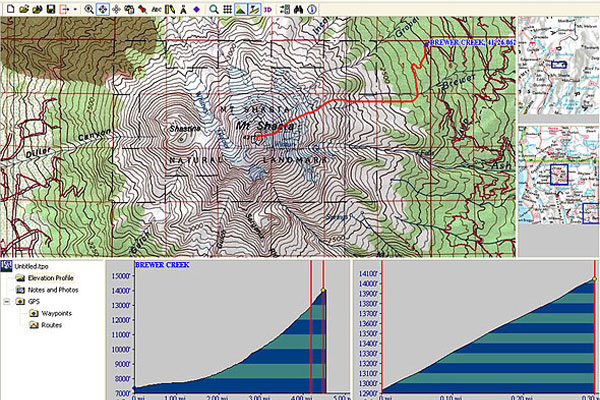
Once you've created a route—say, from the Brewer Creek Trailhead to the top of Mount Shasta—Topo! will build a profile of it. Topo! then displays a bevy of useful information about the route you've created, including a scaled cross-section profile. In this case, we can see that it's 4.73 miles from the trailhead to the summit, with a formidable elevation gain of 6710'
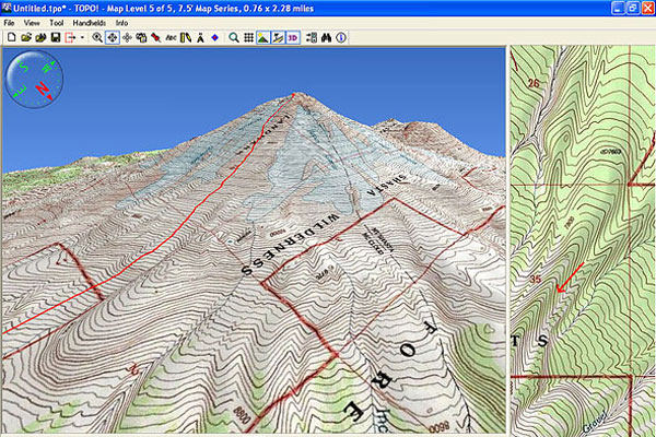
Route-creation and profiling features are easily among the more compelling reason to get this software. The flashiest feature, however, is Topo!'s ability to generate three dimensional views from USGS quads. Topo's ability to turn flat, lifeless USGS Quads into vivid 3D-renderings is simply stunning. No longer will the map-challenged among us struggle to visualize topography from all those tiny, wavy lines.
While the rendering is top-notch, the interface unfortunately is not. If you've spent any time with today's top 3D games, you'll quickly realize that National Geographic's 3D navigation is rather clunky. Simple tasks like zooming, panning, and moving the camera are tedious. You can't drag the map in 3D to see bordering terrain, nor can you create your routes by drawing on the 3D view (which would be particularly useful).
Topo! gives you the ability to print custom maps with considerable freedom. Scan resolution unfortunately is fairly low, but you can print in full color, which helps, and certainly resolution is good enough to see individual contour lines on the end result. Yes, we have Google Earth today, which is free and offers vastly better 3D resolution. But you'll still want to check a map now and then, and for that, Topo! can't be beat.

Arcade Belts National Geographic
$22.99 at OMCgearArcade Belts National Geographic
$22.99 at OMCgear
National Geographic California
$34.95 at REI.com
National Geographic Pacific Crest
$24.95 at REI.com
National Geographic Death Valley
$14.95 at REI.com
National Geographic National Parks
$99.95 at REI.com


 Smith Parallel
 North Face Base Camp
 GoPro HD Hero2
 BearVault Solo
 Black Diamond Ion
 National Geographic Topo!